| Author
|
Thread |
 
|
|
April
Joined: 13 Dec 2003
Posts: 6593
Location: Westchester/NYC11/2/14 10:52 AM |
Garmin...
So I'm in the process of boxing up my Garmin Edge Tour to return it to REI.
All I wanted is for the unit to beep me when a turn is up. It's failing rather more often than I like. I ride with others most of the time, I noticed it's not just my unit that has that same problem.
The root issue was GPS signal. When I ride in area with a lot of foliage, the unit lose the signal and doesn't know where I am. Hence no beep.
My solution is simple, use my bike computer to tell me when I'm due for a turn. If the Garmin beeps, great. If it doesn't, I'll start looking for street signs.
Long story short. I know some Garmin unit can integrate with heart rate monitors or even cadence data. Is there a model that integrates with the speedometer/odometer so it doesn't suffer from missing turns due to losing GPS signals?
|
|
 |
|
|
|
|
|
dfcas
Joined: 11 Jan 2004
Posts: 2815
Location: hillbilly heaven11/2/14 11:24 AM |
The 500/510/800/810/1000 work with the speed/cadence sensor and will read distance when the sat signal drops out. There are 2 speed sensors now, a conventional one and one that goes on the hub.
I tried a speed/cadence sensor with a 510 and the speed was still somewhat flaky. I've given up on Garmins. They need charged too much /have too little battery life/ and are unable to tell me how fast I'm going at the present time.
|
|
|
|
|
|
|
|
April
Joined: 13 Dec 2003
Posts: 6593
Location: Westchester/NYC11/2/14 1:13 PM |
How does the speed sensor work? It said no magnet, no alignment needed. So what does it measure?
I'm less concern about the speed part. More interested on it being integrated to the navigation routine to tell me to turn even when there's no GPS signal.
|
|
|
|
|
|
|
|
dfcas
Joined: 11 Jan 2004
Posts: 2815
Location: hillbilly heaven11/2/14 2:28 PM |
It works like a cell phone measures orientation with an accerometer. Each revolution is measured and a speed/ distance is calculated.
accellerometer damn cell phone
Last edited by dfcas on 11/2/14 2:59 PM; edited 1 time in total
|
|
|
|
|
|
|
|
April
Joined: 13 Dec 2003
Posts: 6593
Location: Westchester/NYC11/2/14 2:46 PM |
ok, so some Garmin has distance information independent of the GPS signal.
But I don't get the impression they're using it to help with navigation (turn alert). Because every time I rode past the turn, my buddies with 800 series rode right past the turn with me without a beep from their Garmin!
I don't know if any of them uses the Garmin speed sensor though. I might have to do another experiment come next season.
I've only had my current model for 2 months and it left me underwhelmed. Still, when it works, it's quite nice. It's just it failed so often it's really quite useless overall. (there're a lot of other minor annoyance too, but I can live with those if the turn alert works better than 90%. Sadly, where I ride, it failed far too often)
|
|
|
|
|
|
|
|
dfcas
Joined: 11 Jan 2004
Posts: 2815
Location: hillbilly heaven11/2/14 2:59 PM |
I don't think it uses distance to determine current location-just GPS.
|
|
|
|
|
|
|
|
greglepore
Joined: 10 Jan 2004
Posts: 1724
Location: SE Pa, USA11/2/14 3:22 PM |
The 500 is notorious for late notification, the only workaround is to use a premium service like ridewithgps which places the markers before the turn.
The 800 is much better, primarily because it has better gps reception.
The 510/810 have better ant+processing and somewhat better gps reception, but have had firmware issues, mostly resolved now.
|
|
|
|
|
|
|
|
Tim123
Joined: 01 Apr 2004
Posts: 252
Location: Adelaide11/2/14 4:23 PM |
My 500 used to lose track of where it was from time to time, I don't use it for navigation though, my 510 hasn't missed a beat yet with GPS reception. The 510 uses dual sattelite reception, standard and the Russian GLONASS one which seems to help a lot. For some reason the 810 doesn't have the GLONASS feature in it so not sure if it is as reloable as the 510 in that respect.
|
|
|
|
|
|
|
|
sandiway
Joined: 15 Dec 2003
Posts: 4902
Location: back in Tucson11/3/14 11:18 AM |
Why don't you try your cellphone? See if that's better...
Sandiway
|
|
|
|
|
|
|
|
April
Joined: 13 Dec 2003
Posts: 6593
Location: Westchester/NYC11/3/14 11:22 AM |
cell phone
Not enough battery life to last the ride
(also don't want to mount it on the handlebar in case I take a tumble, in which case I would need it to call for help)
|
|
|
|
|
|
|
|
Sparky
Joined: 08 Dec 2003
Posts: 19083
Location: PDX11/3/14 12:11 PM |
Rubber side down, tech side up. ;)
|
|
|
|
|
|
|
|
sandiway
Joined: 15 Dec 2003
Posts: 4902
Location: back in Tucson11/3/14 2:16 PM |
Use an old phone. Since people are upgrading every few years, repurpose an old iPhone. Battery life? Plenty of usb battery packs available.
|
|
|
|
|
|
|
|
April
Joined: 13 Dec 2003
Posts: 6593
Location: Westchester/NYC11/3/14 2:21 PM |
old phone?
I don't get how it'll work.
Old phone or new phone, wouldn't it need to have data link? That would cost considerable extra.
Besides, smartphones are a whole lot bigger than Garmin (ok, that's actually an advantage when it comes to map display, except I'm already running pretty tight on bar top real estate). Add extra battery pack, that's a lot of extra pieces to carry around.
|
|
|
|
|
|
|
|
sandiway
Joined: 15 Dec 2003
Posts: 4902
Location: back in Tucson11/3/14 3:36 PM |
Some mapping apps can have downloaded maps and don't require a live connection.
Also the phone will function on wifi at home.
Sandiway
|
|
|
|
|
|
|
|
April
Joined: 13 Dec 2003
Posts: 6593
Location: Westchester/NYC11/3/14 4:05 PM |
too much hassle.
cue sheet works fine so far. looking for improvement, not distraction
|
|
|
|
|
|
|
|
sandiway
Joined: 15 Dec 2003
Posts: 4902
Location: back in Tucson11/3/14 6:53 PM |
quote:
cue sheet works fine so far. looking for improvement, not distraction
I thought you were looking for a gps map program. Especially, if you use a phone with no phone capability, how can it be a distraction?
quote:
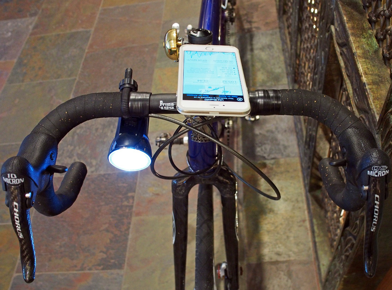
except I'm already running pretty tight on bar top real estate
Look at mine. That Japanese bell. A Cateye headlight. An iPhone 6 plus. Still space left over.
|
|
|
|
|
|
|
|
ErikS
Joined: 19 May 2005
Posts: 8337
Location: Slowing boiling over in the steamy south, Global Warming is real11/3/14 7:03 PM |
I would sweat your 6+ into oblivion. I have nothing on my bar these days. I see my ride on Strava when I get done.
I don't normally see a need for routing or directions even. Most sponsored rides are very well marked, with symbols on the road and signs etc.
Do you really need a device to point for you? I truthfully have never found the need.
I use my phone for directions when driving in strange areas etc but I have never needed it on a bike and I have ridden all over the world.
|
|
|
|
|
|
|
|
sandiway
Joined: 15 Dec 2003
Posts: 4902
Location: back in Tucson11/3/14 8:01 PM |
My iPhone 6 plus is simply running Wahoo Fitness. I have a bluetooth HR strap. GPS supplies the speed/distance data. I don't bother to download the data. A glance at the graphs shows me what I need on my training route:
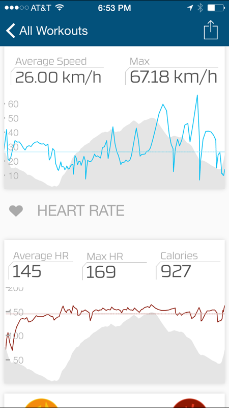
(This was tonight's 1 hr sunset training ride.)
I don't typically run anything else, though obviously I can use Apple or Google Maps, Yelp or look for a gas station/convenience store out there in the desert if I decide to customize a longer ride on the fly.
If I thought I needed a Garmin 1000, I'd have one on my stem top. But the iPhone is so much more powerful and flexible, I don't think it's worth paying for another device.
|
|
|
|
|
|
|
|
April
Joined: 13 Dec 2003
Posts: 6593
Location: Westchester/NYC11/3/14 8:11 PM |
Erik, thanks for clearing up a lot of things.
"
Most sponsored rides are very well marked, with symbols on the road and signs etc.
"
I very rarely do sponsored rides these days. D2R2 being the exception, a ride that has no marking!
So...
"
Do you really need a device to point for you?
"
YES!
For one thing, how do you suppose the "sponsors" came up with the route? It's because the local riders put them together. I've been exploring my own local area roads that many riders didn't know exist. So no markings to rely on. Sometimes, they don't even bother with street signs!
While I don't "need" the Garmin, I could see clearly the benefit it could potentially provide: I layout the route on the computer and download it to the Garmin so I can follow it without stopping to look at a map frequently.
That's the ONLY reason I wanted the Garmin do. And THAT is why I'm returning the unit. It doesn't do it well enough to be worth the $250
"
I use my phone for directions when driving in strange areas etc but I have never needed it on a bike and I have ridden all over the world.
"
I too, have ridden in a lot of "strange areas" too. I never gotten lost per se, despite not having a GPS.
But I'm not going to kid anyone by saying I don't wish I have something that works better than a map/cue sheet!
To Sandiway, no I don't need a mapping app. I need a "device" to alert me the turns on a route that I downloaded from the mapping app on a computer. Once I'm on the bike, I don't really want to deal with any "apps" any more. It should be as unobstructed as possible.
|
|
|
|
|
|
|
|
sandiway
Joined: 15 Dec 2003
Posts: 4902
Location: back in Tucson11/3/14 9:20 PM |
quote:
To Sandiway, no I don't need a mapping app. I need a "device" to alert me the turns on a route that I downloaded from the mapping app on a computer. Once I'm on the bike, I don't really want to deal with any "apps" any more. It should be as unobstructed as possible.
I think you do want a mapping app. It can have your downloaded route and maps for the area. No need to access the cellular data. Then when you make a wrong turn, the mapping will get you back on course.
The beauty of the phone ecosystem is that you can try different mapping applications until you find one that meets your needs. Or you can wait for Garmin to fix their software...
Sandiway
|
|
|
|
|
|
|
|
April
Joined: 13 Dec 2003
Posts: 6593
Location: Westchester/NYC11/3/14 10:12 PM |
I don't believe it's a software problem, Sandiway.
When the Garmin lost its position, I tried my phone. It too, didn't know where it is.
Short of a better antenna, or ride only in open areas, this is a physics issue rather than a software issue.
But there's a solution which no one is employing: use the speed/distance data from the bike itself to help calculate location! Just like how we use cue sheets!!!
I know Garmin has speed sensor. So I was hoping it uses that data to help navigation when it can't find the satellite. But apparently Garmin decided not to.
Where I'm riding, a pre-loaded map beats maps that loads on demand due to poor cell signal coverage. So, a phone isn't the best option unless it already cached the map. And it really doesn't add much benefit.
For the most part, I don't use the mapping function because I tend to do that from the computer. There's no "getting lost" to speak of. Only missed turns and resulting U-turns. And occasionally, turning into the wrong street in a 6 way junction!
(there's been times I need to cut off a chunk of the route. But I don't ask the Garmin to do that for me. I find it on the map (on Garmin or on my phone) that connect me to intersect a latter point of the route. Usually pretty straight forward. )
I hope my club-mates don't read this. One of the main reason I don't use the mapping option of any navigation program is I'm not looking for the flattest nor shortest road connecting point A to point B. I'm usually looking for roads that has the least amount of traffic, hills and dirt roads be damned! Most mapping apps don't have that as an option! It's not the "usual" requirement for most riders either. Some of my buddies are threatening to nominate me for the "Marco Polo" award for finding the most obscured roads in the region! I'm also at risk of getting the Pinocchio award for always underestimate the climbing involved...;-)
|
|
|
|
|
|
|
|
mag7
Joined: 11 Jan 2004
Posts: 888
Location: Lake James, NC11/4/14 12:28 AM |
Wahoo offers the RFLT+ which allows you to store your phone wherever you like (jersey pocket, seat bag, etc) with the display turned off and transmits ride data to a remote display device (RFLT+ pronounced "reflect plus") mounted on your bar.
I have that setup along with the heart rate strap Wahoo sells.
|
|
|
|
|
|
|
|
Nick Payne
Joined: 10 Jan 2004
Posts: 2626
Location: Canberra, Australia11/4/14 12:37 AM |
Solar flares
Maybe this is the reason:
http://www.bikeradar.com/road/news/article/solar-flares-could-cause-garmin-glitches-42859/
- though Garmin claim in that article that their units aren't affected.
I have a Garmin Edge Touring and I've never had any problem with the turn indications not coming in good time. But then Australia doesn't have very many heavily forested regions - the only time I've found the unit to lose GPS lock is under bridges or in tunnels. And maybe another possible difference is that my Garmin is a European unit. which only comes with European maps, and the map that I'm using for Australia is the OpenStreetMap routable bicycle map downloaded from
http://garmin.openstreetmap.nl/
.
|
|
|
|
|
|
|
|
ErikS
Joined: 19 May 2005
Posts: 8337
Location: Slowing boiling over in the steamy south, Global Warming is real11/4/14 5:36 AM |
Strava does turn by turn routes, though I have never really used the feature. Once again a phone may be a more flexible option for you.
|
|
|
|
|
|
|
|
greglepore
Joined: 10 Jan 2004
Posts: 1724
Location: SE Pa, USA11/4/14 6:04 AM |
rflkt+ doesn't offer access to gps or text or caller id. Just music and speed/hr/power data. And its buggy. I was a big advocate, ditched it for a Garmin 500 and didn't look back.
|
|
|
|
|
|
|
|
 CYCLING TECH TALK FORUM